 |
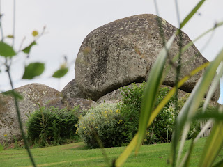
| Sanduck Grove Tor |
This walk had been in the planning for not too long now, but it was one that I would have to do in order to clear up some of my remaining tors - and despite bagging some of my first tors in Lustleigh, I was also, because there are so many, bagging some of my last here, too - and even after this walk I am not done yet!
I got dropped off at the top of the village, walking down to the village centre where I met
Paul Rendell to begin the walk. The route I drew up the night before seemed all good, as we passed through the orchard where May Queen Stone (new) resides, but something wasn't right as we began ascending and turned right to reach two small bridges over the Wray Brook.
 |
| May Queen Stone (new) |
 |
| May Queen Stone (new) |
 |
| Crossing Wray Brook, lower outcrops of Pathfields Tor behind |
I had never been on this footpath before, and when I saw where it took us out, at Pathfields Tor, I was stunned. We didn't head right up to the tor, choosing to continue through the gap between two fields where we would find a gap in the hedge to view the beautifully situated Highfield House Tor - even if the main part is out of reach.
 |
| Pathfields Tor |
 |
| Pathfields Tor |
 |
Highfield House Tor
|
|
 |
Highfield House Tor
|
|
 |
| Highfield House Tor |
|
 |
| Highfield House Tor |
|
We reached the road, known here as 'Mapstone Hill', where Parson's Brown Loaf resides. The huge, domed boulder is given this name by both William Crossing and
old OS Maps. This is one of the most difficult rocks on my list to photograph.
Into new territory for me, we passed a post box and a few slotted gateposts, one of which while not slotted was to be found embedded in a wall at SX 77687 82528. We had hoped to see Higher Combe Cross from the roadside, as
Dartefacts shows, but the grasses were too high to give us even the slightest of views.
 |
| Parson's Brown Loaf. Rock basin on top, although good luck getting to it! |
 |
| Post Box by Combe House SX 77983 81818 |
 |
| Slotted Gatepost by South Hill SX 77930 82145 |
 |
| Pair of Slotted Gateposts, near Higher Combe SX 77676 82531 |
We soon reached the turn off where we entered Sanduck Grove. We quickly nipped up a track to a possible outcrop at SX 77389 82851, though at this time of year it hardly deserves a second glance. We dismissed it and made back for the public footpath through Sanduck Grove. I almost walked past the sign!
Entering the Grove the smell of pine became apparent; it was akin to Fernworthy Forest in here. Beautiful. Immediately, to our left and ahead, we spotted the tor we were seeking, a characteristic rockpile called 'Sanduck Grove Tor' by Tim Jenkinson in 'Dartmoor Magazine Issue 133 Winter 2018: The Rock Piles of East Dartmoor: The hidden landscape Part 2'. Paul Rendell, however, knows this as 'Higher Combe Tor' after speaking to a local. Either way, it can be found at SX 77331 82681.
The tor although on private land can literally be bagged from the footpath which, when looking at different versions of OS Maps, appears to have been rerouted or there is more than one public right of way through the Grove, OS Maps marking the one above the tor and dismissing the lower - the one we took. It's all a bit confusing!
 |
| Small, overgrown outcrop near Lower Sanduck SX 77389 82851 |
 |
| Sanduck Grove Tor aka Higher Combe Tor |
 |
| Sanduck Grove Tor aka Higher Combe Tor |
The footpath speedily left the forest behind, entering a beautiful range of manicured fields in the ground of Higher Combe. The footpath jumped around a bit; it was important that we always had our heads up to observe the signage as to not accidentally walk into someone's private property.
We entered a woodland en route to Middle Combe in the hope of spotting the lower outcrops of what Tim Jenkinson has appropriately termed 'Middle Combe Tor'. We first passed an outcrop above a gate marked as 'private' before noting a narrow path ascending the slope in the next plot ahead. With only a 6-figure NGR, this outcrop took some time to find, but we did find it at SX 77771 82126. Once I confirmed we were at the tor, we retreated to the safety of the footpath.
 |
| Outcrops north of Middle Combe Tor |
 |
| Middle Combe Tor |
 |
| Middle Combe Tor |
 |
| Middle Combe Tor |
We headed south to Lower Combe crossing over a small clapper bridge before tackling the ascend to Hammerslake. Having walked this stretch only back in
February, I can confirm that, as expected, summer is perhaps not the best option if you get claustrophobic - hence why we missed out Cothland Tor.
We reached the road, having a quick drink at the stile, before making our way south to get as close as we could to the forbidden Ellimore Tor. The gate which once provided access is now padlocked with a private sign, but fortunately, the tor can be seen from the road.
 |
| Small Pile at Lower Combe |
 |
| Ellimore Tor |
 |
| Ellimore Tor |
We turned left, descending to the farm of the same name, where we got a decent view of Higher Truckel Tor, a name taken from Tithe Maps for the plot that the tor straddles; the other being Fore Field. In truth, it is better to view the tor from the road to the east, and this is something I would encourage.
 |
| Ellimore Trough SX 77696 81405 |
 |
| Ellimore Trough SX 77696 81405 |
 |
| Ellimore |
 |
| Higher Truckel Tor SX 7783 8141 |
 |
| Higher Truckel Tor SX 7783 8141 |
 |
| Me taking zoomed photos of more rocks - photo by Paul Rendell |
The road soon took on a steeper descent where we passed a lower outcrop of Higher Truckel Tor before getting our first view of Rockholt Tor, a large outcrop hidden in the trees.
 |
Higher Truckel Tor lower outcrop
|
|
 |
Rockholt Tor
|
|
 |
| Rockholt Tor |
|
 |
| Rockholt Tor |
|
Brake Tor was next, and at the driveway entrance is a fine slotted gatepost.
 |
| Brake Tor |
 |
| Brake Tor |
That is the final tor for this blog post. In
part 2, we bag more tors, pass through the pretty hamlet of Pethybridge and walk down to Hisley Bridge and over to Knowle.


Great walk Max, looking forward to part 2.
ReplyDelete