 |
| Wispy Clouds above Fordsland Ledge |
This was, to put it right there, a walk of much interest, and there was so much to see so I have, for once, chosen to go with what I wrote on the Dartmoor 365 Facebook group (hence the square references) as a summary.
I will, however, include more photos to document the day's outing!
 |
| Leaving Belstone |
Wow, what a walk yesterday with the Perambulators! It has been over half a year's wait to finally finish the final leg of the Dartmoor Perambulation, a circular route that closely follows the parish boundary of Lydford - Forest of Dartmoor, defined by the knights who rode the route in 1240. Our final stretch started at B10 Belstone Village, where we took the track that hugs the east side of Belstone Common before ascending over the southern edge of the common to Winter Tor, and thence C9 Cullever Steps.
 | | Winter Tor |
|
 | | Winter Tor |
|
 | | Cullever Steps |
|
 | | Cullever Steps Ring Setting Cairn and Cist |
|
We headed through the magical Hartor Hole, where a combination of cascades and waterslides create a breathtaking soundscape that fills your head with excitement. We crossed the road and briefly traversed some wet ground to take the military track below Rowtor to Moor Brook. The ascent to West Mill Tor was steep, just as I remember it, but what a grand tor it is. Every time I revisit it moves up my list of favourite tors. It is for me the best tor in the area, its huge granite stacks dominate from all directions and the views are outstanding. While the Perambulators had a break, I took to climbing the tor to the core stone to soak up the vistas. A really memorable tor.
 | | Cullever Steps B.S, Boundary Stone on Old Maps |
|
 | | Hartor Hole Cascades SX 60262 91991 |
|
 | | Black-a-ven Brook Ford or Hartor Ford |
|  | | West Mill Tor |
|
 |
| West Mill Tor |
 |
| West Mill Tor |
Passing the lovely cow pats of Little Tor, we rejoined the track, crossing the Red-a-ven, where Sheron asked if I had been to D8 Pixie's Pool. I said no so that was where we headed, but I wasn't missing much. I'm sorry to those of you who like this square and the plantlore here, but I honestly can't think of a square I'd rather not revisit. I struggled to discern a pool and the ground was not pleasant. The climb to High Willhays was fun, though, and we admired the views while trying not to get blown off the top!
Note: Yes, I know that a checkpoint on the Perambulation is Ernestorre which is generally accepted to be Yes Tor, and we had intended to visit, although it all got a bit messy as we opted to take the military track after Little Tor and then visit Pixie's Pool which is below High Willhays. Ebdon suggests that Ernestorre may refer to that tract of land around the Black-a-ven in the vicinity of New Bridge, or the entire Roof of Devon from Fordsland Ledge to Yes Tor, including High Willhays, the highest point.
 | | Little Tor |
|
 | | Pixie's Pool |
|
 | | High Willhays |
|  | | High Willhays |
|
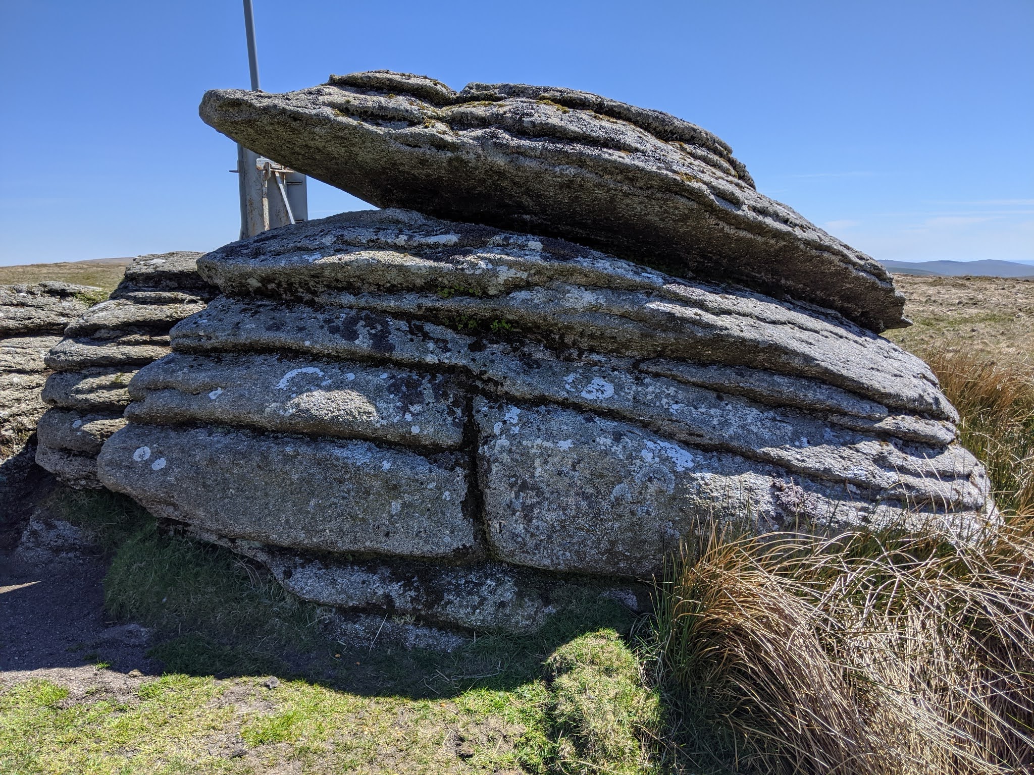
The path lead us to the lovely tor known as Fordsland Ledge, a fantastic viewpoint that is somewhat eclipsed by two military firing range huts. A nearby encircled cairn and cist indicates the importance of this lofty vantage point as a burial site. It was a fun, albeit precarious in places, descent towards Sandy Ford, sometimes walking amid hidden holes where water flows underground all the while trying to avoid the massive clitter fields that stud the valley side. I used robust bin liners (courtesy of Fiona) to get across Sandy Ford, and just above we set up lunch. I had a banana (of course!), and in fact couldn't resist a second as I would need as much fuel as possible to cope with the next objective.
 | | Fordsland Ledge |
|
 | | Fordsland Ledge Flagpole |
|
 | | Descending Fordsland Ledge |
|  | | Sandy Ford, West Okement River |
|
'Cope' might be exaggerating it a bit, as although the ascent up the valley to Steng-a-Tor is horrendously steep, requiring all fours at points, it is extremely good fun as every step takes you higher in altitude where the wilderness opens up, with Black Tor's trio of outcrops beautifully positioned above the copse capturing one's attention. Over the crest, the lonely Steng-a-Tor came into sight, a tor that I really didn't want to revisit because its surrounding bog looms in my mind, but it was on the route so had to be done... and in all honestly, I want to apologise to the tor. Yes, I did almost lose my left foot once again below the tor, but as I was first here I took the opportunity to scale it and sit atop the granite sentinel to gaze upon the rolling hills. The shape of this tor and its added isolation are factors that appeal to me... I have been converted by 'The Camel'! We took a side trip to a nearby outcrop, known to Paul Rendell as 'Little Steng-a-Tor', though to me, this is merely an outlier of the main attraction, but I did find a lovely logan stone, which btw actually rocks, much unlike its neighbour.
 |
| Ascending the West Valley Side of the West Okement Valley |
 |
| Steng-a-Tor |
 | | Steng-a-Tor |
|
 | | Paul Rendell's 'Little Steng-a-Tor' SX 56736 88094 |
|
Kitty Tor sat on the horizon and we sheltered behind the range huts because the wind was relentless by this point. I left the group to search for a benchmark on the summit outcrop which is the detached rock further up the hill with the flagpole. I indeed found it, but struggled to photograph it. I rejoined the team just below, bumping into Karl Woodridge aka Dead Fall Outdoors (on YouTube and Instagram), and it was great to catch up.
 | | Kitty Tor |
|
 | | Kitty Tor |
|
 | | Kitty Tor |
|
 | | B.M. 1916.9, E facing on Kitty Tor, Top of Rock SX 56689 87284 |
|
Rattlebrook Head is a checkpoint but the going looked perilous so we unanimously chose to head to F6 Rattlebrook Peatworks via the waymarked path. This was another new square, or rather feature as I had visited Bleak House before, which sits in the same square. It contains numerous incised bricks and remains of buildings. A bridleway heads south, initially very obvious but eventually fizzling out as it approaches Bleak House (Dunnagoat Cottage). Below the ruin, we crossed the Rattle Brook on a clapper bridge and followed the right bank downstream to the next ford which marked, for us, the 'official' end of the Perambulation. Whoopee!
 | | Wooden Bridges at Rattlebrook Peatworks |
|
 | | Rattlebrook Peatworks |
|
 | | Rattlebrook Peatworks |
|
 | | Bleak House or Dunnagoat Cottage |
|
 |
| Rattle Brook Lower Ford |
Sheron had remembered a tethering ring being located in the vicinity, so I checked Dartefacts but inadvertently found the wrong listing (and hence NGR), but Sheron did find an iron ring on a large boulder which is probably the correct site for both items. It was simple now, the route, taking the peat track down to Dick's Well and the Lydford/Bridestowe & Sourton parish boundstone. We could see G5 Brai Tor and Arms Tor on the horizon, below us, and I remarked how the former possessed a benchmark, so we visited because it is rare that anyone descends to the tor; it is infamous for being a steep climb at the beginning of a walk! I took things a step further; I checked Dartefacts and confirmed that another benchmark was close by and should be visited, which Fiona politely mud painted to make it more discernible.
 | | Rattlebrook Tethering Ring, Large Boulder SX 55834 86018 |
|
 | | Rattlebrook Tethering Ring, Large Boulder SX 55834 86018 |
|
 | | Rattlebrook Peat Track |
|  | | Approaching Dick's Well |
|
 |
| Brai Tor |
 |
| B.M. 1419.7, S facing |
As we dropped behind Brai Tor, we were sheltered from the wind, but the intensity of the heat became apparent, yet it hardly mattered as we were not far from the finish. F4 High Down Ford was reached and because of the low river levels, it felt only right to use the stepping stones. The end of the walk, at High Down, was within spitting distance and we all felt accomplished to have made it to the end, perhaps not in record time (!), but with great company and weather, I should add, throughout. I am grateful for the opportunity to walk this ancient route and I'm looking forward to my next challenge - the Lych Way.
 |
| High Down Ford and Stepping Stones |


No comments:
Post a Comment