 |
| Higher Stonelands Tor |
Continuing our walk from the magnificent Bowden Tor (it's only taken me some 14 months!), we are now on the road, heading down to Lower Bowden Farm.
Bowden Hill Rocks
Just before this, a small copse to the left reveals a small outcrop, marked on old OS maps, on a steep slope with a ditch below it. Luckily for me, the field gate was open (this is
private land) and I managed to get closer but it's just too heavily vegetated to appreciate.
For the purposes of documentation, I have dubbed this as 'Bowden Hill Rocks', as that is the name used on the
Tithe Map of the Parish of Hennock. It can be located at SX 8203 8034.
 |
| Public Footpath Higher Bowden |
 |
| Bowden Hill Rocks |
 |
| Bowden Hill Rocks |
 |
| Bowden Hill Rocks from the road that bisects the tor |
 |
| Cows at Lower Bowden |
We now follow the road southwards to reach Furzeleigh Cross at which there is a small handy car park for those who wish to explore the southern edge of the woods.
The next section is arguably the most difficult on this whole walk. Stonelands Waste is exactly that, a waste of scattered rocks and overgrown vegetation. I have done the tor here on several occasions, and from experience, I would recommend taking Little John's Walk down from Furzeleigh until you reach the large wooden gate on the right.
Stonelands Waste Tor
It takes you onto a good track (much easier than contouring the hillside above) which you will shortly leave to steeply ascent the huge tor known as Stonelands Waste Tor at SX 8182 7991, part of which is known as 'The Grotto' by David Ayres.
 |
| Stonelands Waste Tor |
 |
| Stonelands Waste Tor |
 |
| Stonelands Waste Tor |
 |
| Stonelands Waste Tor |
Long Close Tor
This is another horrible section, heading directly north, pretty much backtracking back to Bowden Tor but not quite. Try and keep the field boundary immediately on your right, passing several outcrops, until you reach the beautiful Long Close Tor at SX 8176 8016, the name of 'Long Close' being marked on Tithe Maps for this particular plot.
The main outcrop has been nicknamed 'Caravan Tor', and it is a strange name for a tor, I agree, but it is mentioned in James Clapham's Dartmoor Climbing Guide. In addition, Jason Maddick tells us; "There was (when first discovered 20 years ago) a caravan in the field just the other side of the hedge boundary."
 |
| Long Close Tor, nicknamed as Caravan Tor |
 |
| Long Close Tor, nicknamed as Caravan Tor |
 |
| Long Close Tor, nicknamed as Caravan Tor |
Middle Stonelands Tor
The next section was another horrid one, and this time I had to crawl under low trees and ivy to reach the 'wood path' near an outcrop I named as 'Middle Stonelands Tor' due to its position being surrounded by tors with 'Stonelands' in their names; Stonelands North Tor, Lower Stonelands Linhay Tor, Stonelands Stack, Stonelands Waste Tor, and Higher Stonelands Tor.
 |
| Middle Stonelands Tor |
 |
| Middle Stonelands Tor |
 |
| Middle Stonelands Tor |
 |
| Middle Stonelands Tor |
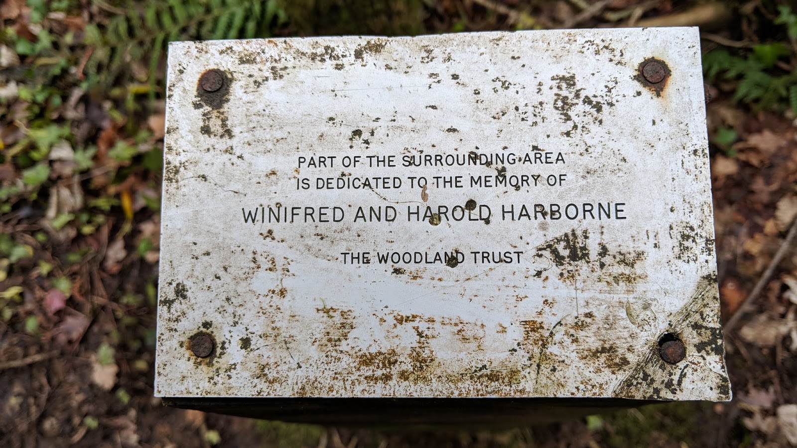
Close to the tor are two plaques, both of which are dedicated to those of loved and cared for the Woodland Trust, one of which reads:
PART OF THE SURROUNDING AREA
IS DEDICATED TO THE MEMORY OF
DOUGLAS ALICK BURRELL 19-20-1981
AND
PHYLLIS ELAINE BURRELL (nee Breed) 1927-1986
THE WOODLAND TRUST
 |
| Plaque near Middle Stonelands Tor |
 |
| Plaque near Middle Stonelands Tor |
Higher Stonelands Tor
Heading south on the 'wood path', you come across a split; ignore the track that veers off to the left as this one heads below the immense outcrops of Stonelands Waste Tor and back up to Furzeleigh Cross. Instead, keep right where you will come out on Little John's Walk near the north entrance to Bearacleave Wood. Turn right and descend the Walk until you spot two large, rounded boulders on the right. These are the upper outcrops of Higher Stonelands Tor above the house and if you can negotiate the fallen trees, you should stumble upon a larger pile at SX 8154 7989.
 |
| Higher Stonelands Tor upper boulders |
 |
| Higher Stonelands Tor one of the upper boulders |
 |
| Higher Stonelands Tor |
 |
| Higher Stonelands Tor |
John Cann's Rocks
If you rejoin the Walk and head down to the bottom of the hill, at Stonelands, on your right, you will notice a large pile of granite boulders which form the lower section of William Crossing's John Cann's Rocks - though on Private Land. Heading back up the hill the highest part of the tor is on the right above a steep embankment and cannot be seen from the Walk.
So-named in the author's (1909) 'Guide to Dartmoor', there is a legend attached to the dark, shadowy tor. Writer Steve McKeogh gives an insightful account in Dartmoor Magazine, No.32, 1993.
To continue the final part of this adventure, you will need to get back on Little John's Walk to reach the north entrance to Bearacleave Wood, where you cannot fail to miss the National Trust sign.


No comments:
Post a Comment